File:Gh-map.png
No higher resolution available.
Gh-map.png (336 × 360 pixels, file size: 10 KB, MIME type: image/png)
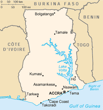
Русский: Карта Ганы
This image is in the public domain because it contains materials that originally came from the United States Central Intelligence Agency's World Factbook.
|
 |
derivative works
Derivative works of this file: Gh-map-sv.png
File history
Click on a date/time to view the file as it appeared at that time.
| Date/Time | Thumbnail | Dimensions | User | Comment | |
|---|---|---|---|---|---|
| current | 04:57, 12 Fepuari 2022 | | 336 × 360 (10 KB) | Lojwe | Cropped 1 % horizontally, 1 % vertically using CropTool with precise mode. |
| 18:07, 13 Iuni 2005 |  | 341 × 365 (10 KB) | Dubaduba~commonswiki | {{PD-USGov-CIA-WF}} |
File usage
The following page uses this file:
Global file usage
The following other wikis use this file:
- Usage on ady.wikipedia.org
- Usage on be-tarask.wikipedia.org
- Usage on be.wikipedia.org
- Usage on cv.wikipedia.org
- Usage on cy.wikipedia.org
- Usage on da.wikipedia.org
- Usage on dsb.wikipedia.org
- Usage on en.wikipedia.org
- Usage on eo.wikipedia.org
- Usage on fiu-vro.wikipedia.org
- Usage on hu.wikipedia.org
- Usage on hu.wiktionary.org
- Usage on it.wikipedia.org
- Usage on it.wikinews.org
- Usage on ja.wikipedia.org
- Usage on ka.wikipedia.org
- Usage on la.wikipedia.org
- Usage on li.wikipedia.org
- Usage on mr.wikipedia.org
- Usage on nl.wikipedia.org
- Usage on nn.wikipedia.org
- Usage on pl.wikipedia.org
- Usage on pt.wikipedia.org
- Usage on ru.wikipedia.org
- Usage on sh.wikipedia.org
- Usage on so.wikipedia.org
- Usage on sq.wikipedia.org
View more global usage of this file.